Today might be one of the shortest sections in my entire tubewalk, but it's packed with things to see, and it excels at showing how London is made up of both rich and poor, rubbing shoulders with only the thin veneer of the class system to separate them. It takes in two Royal Parks, the earthy world of the southern railway termini, the Southwark end of the South Bank, and the changing-by-the-minute world of Bermondsey.
I've walked most of this route over the past few years, which is probably a good thing as I wasn't terribly awake for the first few sections. We've just had a bank holiday weekend in England and my head is still enjoying some time off, but as per usual, a short jaunt through the capital has helped clear the cobwebs, even if the weather is still disappointingly grey for this time of year. Just don't expect too much flowing prose, as my creative writing circuits have yet to come back online...
Green Park to Westminster

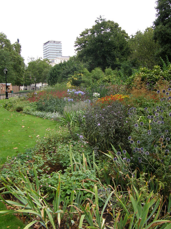
Most of the walk between Green Park and Westminster passes through two Royal Parks, and like all the Royal Parks, they are wonderful. Green Park is the least embroidered of all the parks, and apart from the low-lying Canada Memorial in the southwest of the park, there are no lakes or fountains and precious little flamboyance; the atmosphere is one of gently rolling grassland punctuated with trees, while the grand buildings of St James's line up along the eastern fringe of the park. On a sunny day, Green Park is full of deckchairs and people picnicking; on a gloomy day like today – the first day back at work after the bank holiday and psychologically the end of summer and the start of autumn – even the deckchairs can't be bothered, and they simply sit in piles by the side of the grass.

St James's Park is on the other side of the Mall from Green Park, and is much more manicured than its neighbour. There's a long lake, St James's Park Lake, that runs the length of the park, and a footbridge halfway along the lake has lovely views of Buckingham Palace to the west and the Foreign and Commonwealth Office to the east, each of them framed by the luscious greenery along the lake shore. St James's Park is the oldest of the Royal Parks, which are all owned by the Crown; the swampy marsh that is now St James's Park was bought from Eton College by Henry VIII in 1532, though it wasn't drained until 1603, when James I had it landscaped. It was opened to the public by Charles II after he ascended to the throne in 1660, and though it's been through a few redesigns since – most notably, John Nash designed the current lake, which had previously been a canal – it has been a part of London life ever since.
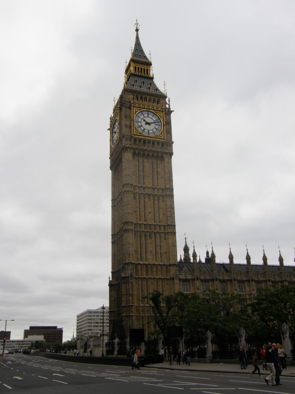
The view east from the park towards Horseguards Parade is a constant delight, and at times it looks positively continental, with all the spires and towers peppering the skyline behind the Parade. The buildings at the southeastern end of the park are no less impressive, with Downing Street and King Charles Street leading off down towards the river. The Foreign and Commonwealth Office and Treasury are deeply impressive buildings, as one would expect, and turning the corner into Parliament Square is quite an event. The Houses of Parliament, and in particular Big Ben, are dead ahead, and even though they seem to be digging up the entire northwest part of the square, it's just as seminal a place as when I walked through here on the District line.
Westminster station cowers beneath the shadows of Big Ben, but even though you can't see much of the station from above ground, the rebuilding of the station to accommodate the Jubilee line extension of 1999 was easily the most complex on the entire extension. Engineers had to excavate a huge volume of earth to house the escalators and lifts to the deep-level Jubilee line, and at 39m from top to bottom, this became the deepest ever excavation under central London. The station lies under Portcullis House, which was built at the same time as the station, and the station deservedly won a number of awards when it opened on . Oh, and Westminster is the first Jubilee line station to have glass barriers between the platform and the track, a theme which carries all the way through the extension.
Westminster to Waterloo

The view from Westminster Bridge is a classic, and with the Houses of Parliament to the southwest and the London Eye to the northeast, it's hard to know which way to turn. Luckily, the council has smothered the northern side of the bridge in hoardings so the choice is a lot simpler, but it does make crossing the bridge a lot less interesting.
It isn't far to the station, and even though it's a busy part of the river, it's hard not to be impressed by the short walk past the old City Hall to the London Eye, even if you've already done it a million times (I've already done it twice on this tubewalk, once on the Waterloo & City line and again on the Northern line). I still love the way the white stone of the Shell Centre dominates the park, with its clean and straight lines complementing the futuristic curves of the London Eye; even under grey skies, Jubilee Park is a lovely place to be.
Waterloo station is on the opposite side of the road to the Shell Centre, and there are entrances to the Tube on the western side of York Road, inside the main station building, and on the other side of the station in Waterloo Road. I already explored the glorious main entrance back on the Northern line, so today I cut through the station itself to get to Waterloo Road. The Jubilee line is on the opposite side of the station to the Northern and Bakerloo lines, though they are joined by a 140m-long moving walkway; the closest entrance to the Jubilee line is the one on Waterloo Road, and when the Jubilee line extension to Stratford was opened on , this entrance was temporarily the western terminus of the extension, as it wasn't linked to Westminster and the rest of the line until (and even then, Westminster station wasn't opened for another month).
Waterloo to Southwark
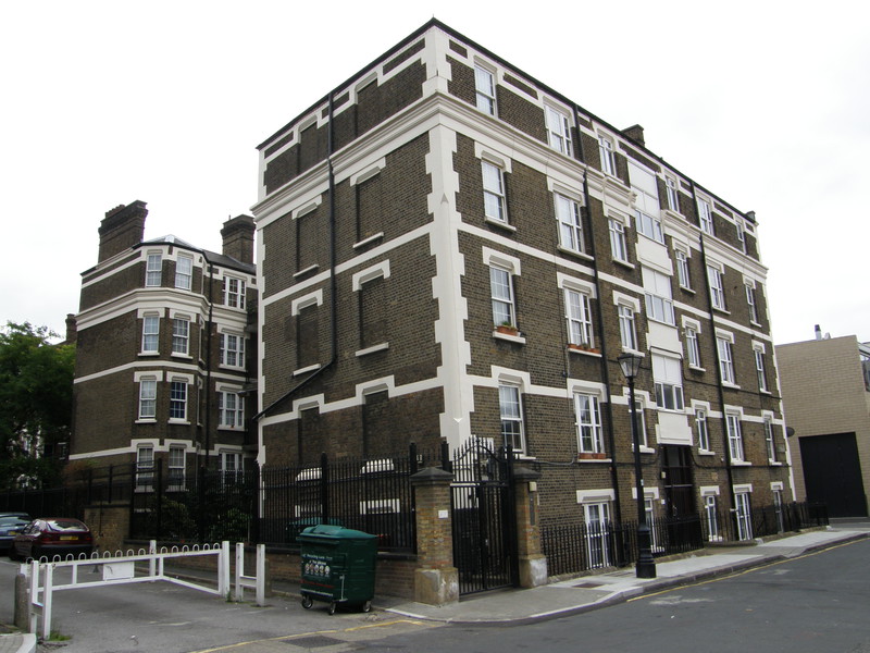
It isn't very far from Waterloo to Southwark station, which is just inside the boundary of the London Borough of Southwark. It might seem odd to create a new station so close to an existing one, but this is a part of the world that could benefit from some regeneration, and the signs are good. It can get a bit gritty around the mainline stations – they somehow seem to retain a slightly industrial Victorian atmosphere, probably because nobody wants to live that close to a train station, leaving industry to fill the gaps – but there are some rather lush modern conversions along Wootton Street that manage to blend in nicely with the surroundings, and along Cons Street are the Peabody Trust's Ipsden Flats, which still look fantastic and demonstrate just how good social housing can look.
Out on The Cut, the main road that joins Lambeth in the west to Southwark in the east, there are plenty of shops and a community vibe that's completely missing from the tourist areas of central London. The Cut is home to two theatres, the Old Vic (at the western end of the road) and the Young Vic (halfway along the road), and at the eastern end of the road is The Ring pub, so named because opposite the pub was the Blackfriars Ring, one of the most popular boxing venues in the 1910s and 1920s (though it was destroyed in the Blitz in 1942, so there's nothing left these days).
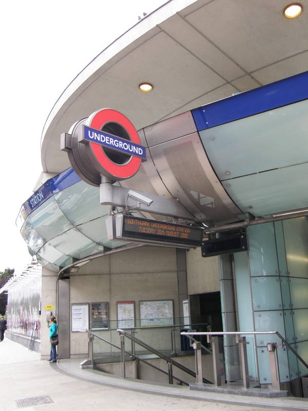
Southwark station is on the junction of The Cut and Blackfriars Road, and we get our first glimpse of above-ground modern station architecture. The entrance is all curved glass and open spaces, and even though it's fairly small, it's perfectly formed. Like Leslie Green's ox-blood red stations, Southwark station has been designed to be built on, and once you know this, it perhaps looks a little lonely, stranded there on the corner with nothing to keep it company. Still, the station's beauty is again underground, this time in the intermediate concourse on the way down to the platforms, which is lined with a blue glass wall that's 40m long and made up of 660 individually cut pieces of glass. Designed by the artist Alexander Beleschenko, it's well worth seeking out.
Southwark to London Bridge
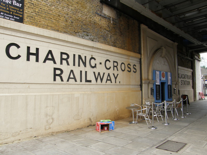
Just north of Southwark station are the remains of a much older station, the original Blackfriars station on the Charing Cross Railway. There was a station here from to on the line from London Bridge to Charing Cross, but the station was closed when the nearby Waterloo East station was opened instead. There's evidence of bomb damage in the glazed tiling from the same bombing raid that destroyed the Blackfriars Ring, and the outside of the station, which houses a small café, has recently been refurbished.
It's a short walk through the backstreets towards the river, and on the way you pass yet more evidence that this part of London is busily being regenerated. There are still some small housing estates and the odd pub hiding away, but the cranes are all around, creating what the marketing departments euphemistically call 'the future of city living.' Perhaps the most impressive of these new developments is the huge Blue Fin Building on the corner of Southwark Street and Sumner Street, which is the new headquarters of the publisher IPC Media and a couple of other Time Warner-owned businesses. The building is covered in metallic blue fins that stick out of the more traditional glass and steel construction, changing its appearance as you walk around it, though it probably looks more impressive in the sun than on a grey day like today.
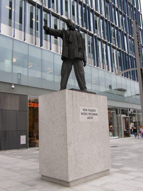
There are plenty of shops on the ground floor – lots of coffee shops and lunch stops, naturally – and there's a statue to the west of the building that's unusual in that it has loose clothes that blow in the wind (though if there's no wind, you can't tell that the clothing is anything other than part of the statue – it's very cleverly done). The Latin inscription on the base of the statue says Non plaudite, modo pecuniam jacite, which means 'Don't applaud, just throw money'; it does look rather like one of the human statues you see loafing around Covent Garden and the London Eye, so perhaps that's what the inscription is getting at, though I'm not sure putting it in Latin is going to win too many wry smiles from passers-by.
Tate Modern is just past the Blue Fin Building, back on the Thames, and the view across the Millennium Bridge to St Paul's Cathedral is as spectacular as it was when I walked this way from Waterloo to Bank on the Waterloo & City line. Back then I walked over the bridge to head for the City, so today I continued where I left off... and this part of the South Bank is a joy to explore. Gone are the wide pavements of the South Bank around Waterloo Bridge, as history is much more squashed in round here, and it makes for a fascinating walk. Just after the Tate is Shakespeare's Globe Theatre, the modern reconstruction of the theatre by the river; the actual site of the Globe is on Park Street, which can be reached via Bear Street (which was the home of Southwark's last bear-baiting ring, a sport that was hugely popular in Tudor times). The site of the original Globe is now private property and sits under the 19th-century buildings of Anchor Terrace, which itself is listed, though there are signs to explain to passing tourists exactly which part of the fenced off area used to echo to the sounds of Shakespeare's plays.
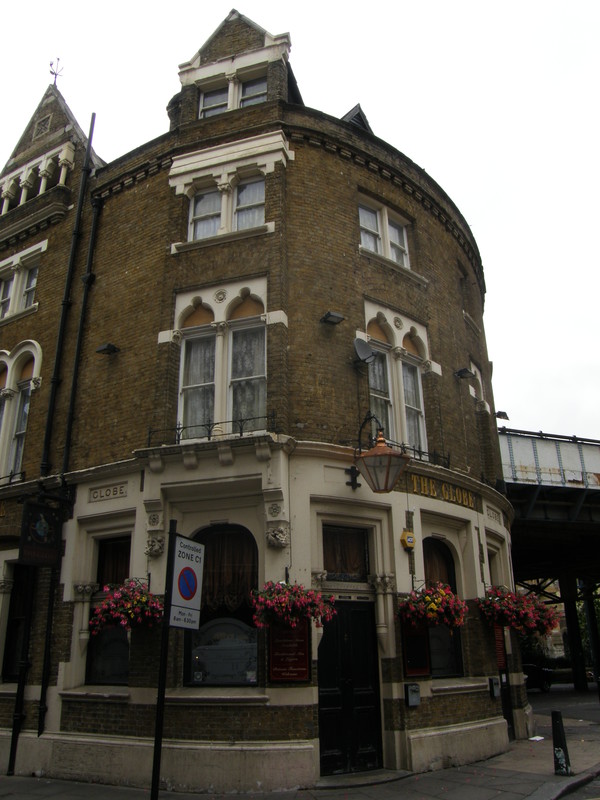
Along Park Street, past a pleasant set of houses built on the site of the old Anchor Brewery, is the historic riverside pub The Anchor. It was from here in 1666 that Samuel Pepys witnessed the Great Fire of London, though the pub itself burned down in 1676 and was rebuilt; the current structure is the result of hundreds of years of additions. Despite this, it isn't the best pub in the world, and is saved only by the riverside terrace that makes for a pleasant stop in the sun; meanwhile, the surrounding buildings are filling up with modern brand names, and Nando's and Wagamama have moved in since I was last here, summing up this part of Bankside quite succinctly.
Along Clink Street you can find the entertaining Clink Museum, the remains of Winchester House (which is currently smothered in scaffolding), and at the end, the Golden Hinde, a scale model of Sir Francis Drake's ship that has itself circumnavigated the globe. Around the corner is the imposing Southwark Cathedral, and the road leads past Borough Market and the Globe pub; the flat above the latter was used as Bridget Jones's apartment in the eponymous movies, though in the book she actually lives in Holland Park.

There are many ways to get to London Bridge station, and I thought I'd take the route along Duke Street Hill and cut through the station from Tooley Street. This turned out to be a popular move, as half of London's tourists seemed to be queueing along the road, presumably to get into the London Dungeon (at least I hope that's what it was for, as there were lots of actors lurking around, dressed up as mental patients and assorted murderers, going up to people in the queue and scaring the living daylights out of them; that must be a satisfying job). The Tube station is buried beneath the arches under the main station, and while there are entrances as far away as Borough High Street, the main entrance is here, on Tooley Street.
London Bridge to Bermondsey
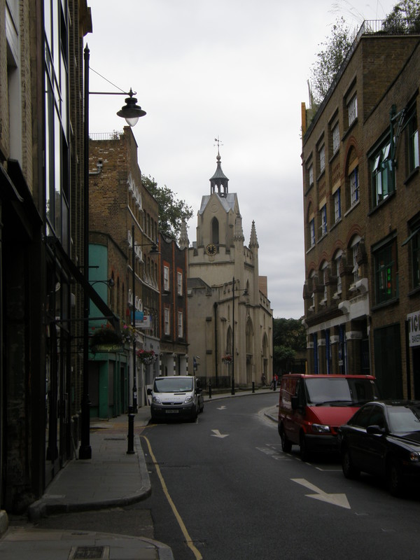
The tourists evaporate as soon as you slip out the other side of the station, past the entrance to Guy's Hospital (which, interestingly, has a McDonald's right by the entrance, like a modern-day money-lender outside the temple). It's a short walk along the edge of the railway embankment to Bermondsey Street, and it's here that the change from tourist central to residential south London is complete, for Bermondsey Street is a lovely place with ne'er a tourist in sight.
The road is lined with all sorts of trendy cafés, restaurants, shops and offices, and there's the old St Mary Magdalen's Church towards the end of the road; there has been a church here since at least 1293, though the current church building dates from 1690, with further work done over the centuries until 1883, when the last changes were made. There's a lovely old rectory next door, and next door to that is a Time and Talents building dating from 1907 (Time and Talents is a local charity that has been working in the areas of community work, social action, education and recreation since 1887).

At the bottom of the street is Bermondsey Square, which is currently shut off by developers finishing off a number of large and rather modern residential blocks in the vicinity; this is the theme for the rest of this walk, with modern blocks rising above existing social housing, both old and new. The Victorian terraces along the first section of Grange Walk are delightful, but on the opposite side of the road, on the site of the old Bermondsey Abbey, the war has been won by relatively uninspiring modern tower blocks, and this is the story all the way along Grange Walk. Some blocks are better than others, but this is not a particularly beautiful part of the world, and it's a relief to burst out onto Spa Road, where there are pubs and shops to break up the housing.
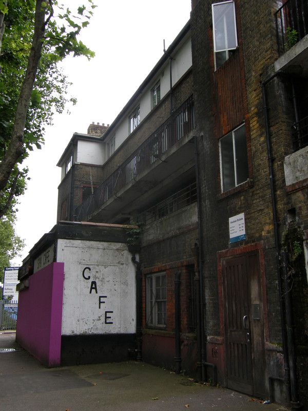
Except, when you look more closely, Spa Road turns out to be a pretty grim place, and the social housing here is absolutely terrible; one block in particular caught my eye, as I thought it was derelict until I spotted the new intercoms on the door and noticed that people were indeed living there. I assumed it must be a squat, but no, this is the Vauban Estate, and from the outside it looks like a Victorian slum. There is currently a one-bedroom apartment for sale in this block for £190,000, though I can't quite believe that anyone would be willing to pay even that. Perhaps it's beautiful on the inside...
The contrast is even more marked when you consider the modern developments popping up along Spa Road like mushrooms after a downpour. This area is called Bermondsey Spa, and you can see the developers' marketing droids lapping this up, as it sounds so much more impressive to be selling a flat in Bermondsey Spa than plain old Bermondsey. The construction of the Jubilee line has breathed new life into this part of town, which was having a pretty tough time of it; but don't take my word for it, for this is what the local council's website has to say:
By the early 1990s, Bermondsey Spa was neglected and run down. The area was badly bombed during the war and despite some house building after 1945, the area was left as something of a forgotten backwater. Apart from a few listed properties, the condition of the buildings was mostly poor, with many vacant or even derelict.
But since the arrival of the Jubilee line, the council has adopted a plan for the so-called Bermondsey Spa Regeneration Area, which involves building over 2000 new homes, 40 per cent of which will be affordable, along with two new health centres, a dentist and pharmacy, new parks, cycle parks, new offices and new shops. It'll be interesting to see how things change over the next few years.
Perhaps echoing this history of being neglected, the site of the old Spa Road railway station lies just to the south, off Dockley Road. This was London's first railway terminus, and was part of the London and Greenwich Railway, which ran from Spa Road to Deptford when it was first opened in ; the line was extended from Spa Road to London Bridge in and from Deptford to Greenwich in 1840, but Spa Road didn't turn out to be a particularly popular stop. The station was moved slightly to the southeast in 1872 and finally closed in 1915, though the line is still in use, and links London Bridge to New Cross and Greenwich.
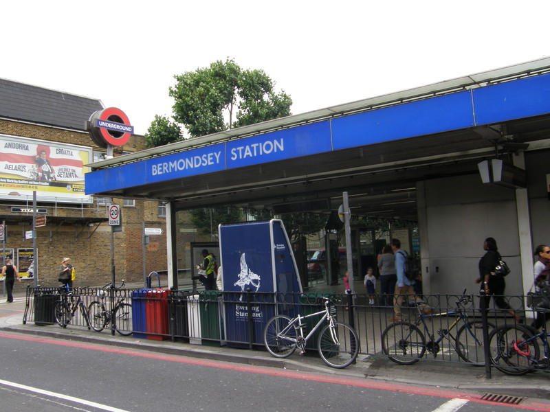
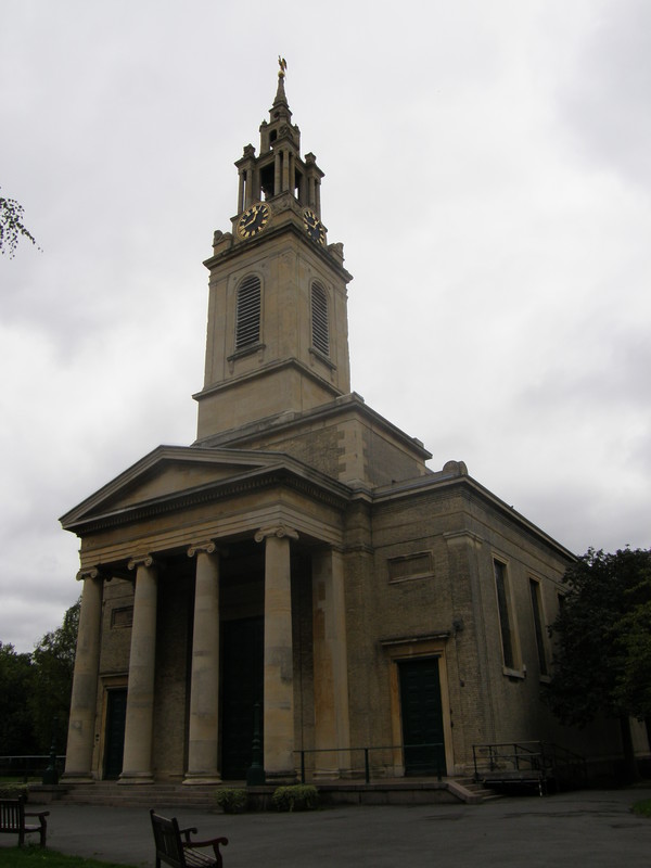
Bermondsey station is out on Jamaica Road, on the other side of the imposing 1829 St James's Church (which, of course, is surrounded by new developments). Another modern station built specially for the Jubilee line extension, it's actually rather disappointing when you consider the potential there was for giving Bermondsey a modern beacon of excellence along its main street. Instead the outside of the building is almost completely bland, with a standard blue-and-white name strip above the entrance but little else to entice passers-by. Inside things are more impressive, with natural light flooding down into the station, but one feels that it might have been kinder to the locals to spend a bit more effort on the exterior, rather than leave them the poor cousins of neighbouring London Bridge and Canada Water.
Bermondsey to Canada Water

Between Bermondsey and Canada Water, just south of the shops and housing blocks of Jamaica Road, is the large expanse of Southwark Park, which makes for an enjoyable stroll after so much urban development. It was opened in 1869 by the Metropolitan Board of Works (who, among other things, built the Thames Embankment) and it was refurbished in 1998 with money from the Heritage Lottery Fund. There's an impressive bandstand in the north of the park that dates from 1884, a velvety bowling green tucked away under the plane trees, and a lake in the south of the park, though I'd turned east by this point to reach Gomm Road. This boasts a lovely row of terraced houses, one of which carries a blue plaque to Richard Carr-Gomm, founder of the Abbeyfield Society, which provides housing and support for older people.

Across the busy Lower Road is Surrey Quays Road, which leads to the deeply impressive Canada Water station. This station is exactly the kind of modern architectural statement that Bermondsey isn't, and its huge steel and glass drum is like a modern take on Charles Holden's Arnos Grove, with even more intriguing design work below ground. There's a glass-roofed bus terminal next to the glass drum, and the only strange part of the whole affair is the clash with the rather ugly tower blocks behind the station, a reminder that this is an ultra-modern station in an area that has yet to catch up. It's yet another analogy with Holden's classic Piccadilly line stations, which were built in the middle of the countryside so they could generate suburbia around them; Canada Water and its ilk will hopefully regenerate suburbia around them, and nine years on from their appearance, the results are starting to show. It'll be interesting to see whether this theme continues along the rest of the extension to Stratford...