Ah well, just because today was my very last tubewalk, that doesn't mean it necessarily has to be a great walk... and I'm afraid it isn't, really. This feels like an unloved and rather disconnected part of London, and combined with the continuing grey skies of summer 2008, it got to me a bit. Despite being joined by my partner Peta for the first half of the walk, I couldn't see the bright side, and stomped through the industrial estates and social housing that line this entire route, counting the miles off to the end. It's not a great way to end three months of walking, that's for sure.
So when I think of the last stages of my tubewalk, I'll think of Wednesday's brilliant walk through the Isle of Dogs and Greenwich instead, and I'll consign this walk to the bottom of my pile of memories. Apart, that is, from the last few steps, which was when I completed my walk of the entire Tube network. That was special, if only because it means I won't have to get up early and go walking in the rain any more...
North Greenwich to Canning Town
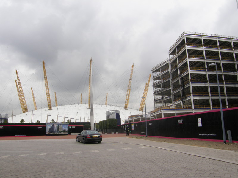
The Jubilee line crosses the Thames three times in quick succession, and it makes life rather challenging for the tubewalker. On my penultimate Jubilee tubewalk, it crossed the Thames between Canada Water and Canary Wharf, and again between Canary Wharf and North Greenwich, and today's walk starts in the same vein. It's just under a mile as the crow flies from North Greenwich to Canning Town, but the most sensible walking route heads southeast from the Dome, along the south bank of the Thames, all the way to the Woolwich Foot Tunnel, from where it's another hike back along the north bank to Canning Town. That's over 7 miles for just one Tube stop, and it's all thanks to the Thames.
Still, it's also thanks to the Thames that things start off in a nice, easy fashion, as the Thames Path continues along the banks of the river, not far from the station. There's a fierce amount of development going on around the Dome and it took us a while to find the riverside path, after a long detour round the large buildings along the shoreline; I'm pretty sure you can join the Thames Path nearer the Dome, which might give you some good views of Canary Wharf and a chance to check out Antony Gormley's Quantum Cloud sculpture in the Thames, but we finally hit the river some way to the south, by which time all the skyscrapers have disappeared and the scene is one of industry on the opposite side of the river and regeneration on this side.

The style of the regeneration is rather strange, though. Not far from the Dome is Greenwich Millennium Village, a large block of apartments that appears to be in the middle of absolutely nowhere, and in a sense this is true. The Millennium Village project was started when the Dome was still going to be a rip-roaring success, but of course, the millennium celebrations fizzled and spat, leaving the Dome unoccupied for years, and the regeneration of this part of the capital has slowed down somewhat from the optimistic projections of the late 1990s. The result is a community of ultra-modern apartments, stuck out on a limb in a quiet and rather dilapidated part of the Thames, and I have to say, to me they look plain weird. Designed to be ecological and futuristic, the Millennium Village's apartment blocks look like multicoloured Lego buildings, and I guess you either love this garish take on the future, or you don't. They don't appeal to me, certainly, though it can't help to be stranded alongside the grey Thames, a long way from the action. There is a park next door – the Greenwich Peninsula Ecology Park, no less, where they were holding mud-painting events when we walked past – but this only seems to heighten the feeling of solitude. Over time the Millennium Village will no doubt grow into its surroundings (and vice versa), but at the moment it feels like the residential equivalent of the Dome, just without the good looks.
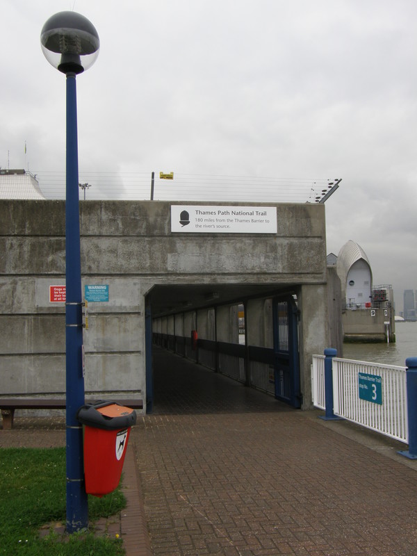
The Thames Path continues past the Millennium Village and weaves through a more industrial landscape, with conveyor belts carrying sand and gravel overhead. There's a lonely pub, the Anchor and Hope, just past the aggregate works, but then the industry kicks in again, taking you all the way to the Thames Barrier. Opened in 1984, the silver domes of the city's flood barrier are a familiar sight, and the Thames Path comes to an end after a tunnel through the barrier, which is lined with a diagram showing the height above sea level of the Thames from the source to the barrier; it must be satisfying to come across this map of the Thames as you finish the 180-mile Thames Path at this very spot. There's a small park on the other side of the barrier, with a large visitor centre, and it makes a good place for a rest in the shadows of the barrier's domes.
At this point, the riverside path disappears for a while, as the Thames Barrier Industrial Estate takes over for a while, but the route round the outside of the estate is well signposted, as we're now on the Thames Path Extension, which joins the Thames Path to the start of the Capital Ring (at Woolwich) and on to the start of the London Loop (at Erith). I didn't realise this, though, and from the visitor centre we tried to bash our way through the estate but to no avail, eventually stumbling on signs for the extension that took us to the Woolwich Road, where I recognised a park entrance on the other side of the road as being from day 1 of the Capital Ring. This is where the Ring heads south to join the Green Chain Walk, so we traced the route of the Ring back towards the Thames, eventually joining the river after weaving through a red brick housing estate; luckily I remembered the route, because as with so many sections of the Ring and the Loop, the locals really enjoy twisting the signposts through 90° round here, and you'll get hopelessly lost if you rely solely on them.
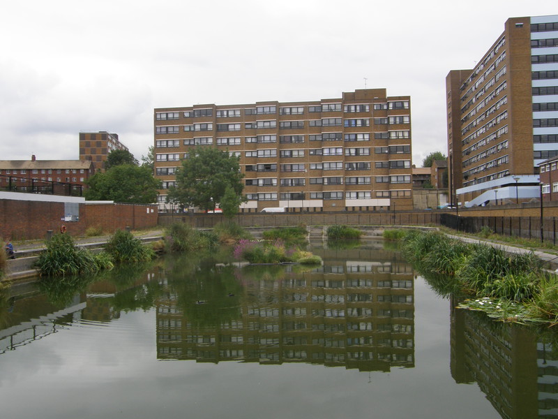
The Ring continues towards Woolwich, past some pleasant enough riverside housing – pleasant, that is, except for the noticeable number of drunks, sucking on their high-octane cans on the benches lining the river – with the huge Tate and Lyle factory dominating the view on the other side of the river. Further on is the Woolwich Dockyard, a naval dockyard that was founded in 1512 by Henry VIII to build his flagship Henri Grâce à Dieu, at the time the largest ship in the world; the docks closed back in 1869, and are now used by local anglers, who were lining the sides as we ambled by. Just past the docks is a large, modern development that is surrounded by scrubland and has a similar air of loneliness to the Greenwich Millennium Village; there's nothing wrong with the apartments, I'm sure, it's just that they look like they've been built in the wrong place, which I guess is the price to pay for being in the vanguard of urban regeneration.
Woolwich Foot Tunnel joins Woolwich to North Woolwich on the other side of the river, and is pretty similar in design to the Greenwich Foot Tunnel. Opened in 1912, the tunnel is a long, round tube, lined with white tiles and accessible both by stairs and by lift (there's a different entrance for each in the domed entrance buildings on either side of the river). It's less popular than the Greenwich tunnel, as tourists don't tend to make it this far, and as such it's rather more eerie walking underneath the river here than further upstream.

At the end of the tunnel is the busy terminal for the Woolwich ferry, which plies its way between the two banks, but it's time to say goodbye to the Thames and head inland, as the riverbanks on this side of the river aren't open to the public. Instead this is the start of a long trudge through a mix of industry, airports, exhibition centres and housing estates, all demonstrating just how the old and the new live right next door to each other in this intriguing part of the capital. Not far from the foot tunnel is North Woolwich, though it's only a short walk west to the edges of Silvertown, where the huge Tate and Lyle factory dominates proceedings. To the north is London City Airport, with the airstrip sandwiched between the Royal Albert Dock and King George V Dock, and the backstreets to the south of the docks are squashed between the roar of the planes and the rumbling of the factories. This is a hard place to love, and although the terraced streets aren't too bad, there's a fairly grim housing estate to the west with some pretty imposing tower blocks, and even the futuristic sweep of the Docklands Light Railway, which serves this whole area on raised viaducts, can't shake the feeling that this is a lonely corner of the world.

Things get a bit more interesting under Connaught Bridge, where the A1020 crosses the docks on a large flyover, while pedestrians creep underneath, cowed by the sheer scale of things. To the east is the Royal Albert Dock, with the runway of City Airport to the south and the distinctive buildings of the University of East London's new Docklands campus at the far end, and to the west is an amazing view along the Royal Victoria Dock towards Canary Wharf, with the monstrous building of the Spillers Millennium Mills to the far left. It was to the left of the mills, on the other side of North Woolwich Road, that one of the biggest explosions in the history of this country occurred at a munitions factory that was producing explosives for use in the ongoing Great War. On , about 50 tons of TNT exploded, killing 73 people and injuring over 400, while destroying 900 nearby properties and damaging up to 70,000 other buildings in the area. The explosion could be heard up to 100 miles away; it was clearly quite a bang.
The area to the south of the dock still looks as desolate as a bomb site, though it is now going to be redeveloped as Silvertown Quays, a £1.5 billion development that will be one of Europe's largest regeneration projects, providing new homes, offices, shops, and leisure and entertainment facilities, over the next 10-15 years. It will be interesting to see how this changes things, as the area to the northeast of the dock already has a slightly corporate feeling, probably due to the nearby ExCeL London exhibition centre and the resulting crop of Premier Inns and businessman-friendly pubs.
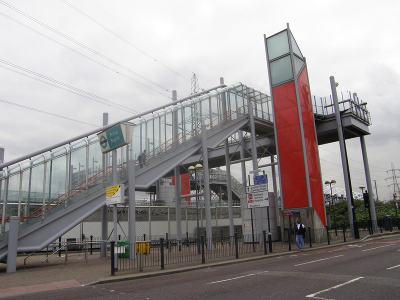
Along Victoria Dock Road are two DLR stations, Prince Regent and Custom House, and they sum up the appeal of the DLR very nicely. I love the way that DLR stations are almost entirely visible, rather than being locked away underground; you can see the station platforms, raised high above the ground, and the lifts and staircases that take you to the trains are laid out for all to see, like a cut-away diagram in a children's book on engineering. The contrast with the Tube is obvious, and the DLR stations are a highlight of walking through this part of town; the fact that they often tower over much older and shabbier buildings is a metaphor for the regeneration of this whole area.
The quickest way to get to Canning Town station is to continue walking along Victoria Dock Road, but I thought I'd explore a bit of Canning Town instead, and turned down Freemasons Road into the heart of the suburbs. On a grey day, this is not a particularly attractive part of town, and rows of box-like terraced houses sit in the shadows of the huge Novotels and Ibis Hotels over towards the exhibition centre. Things improve as you head west towards the station, and apart from the odd tower block, the terraces over here are relatively pleasant inter-war affairs, no doubt the result of the slum clearances that the council instigated round here back in the 1930s.
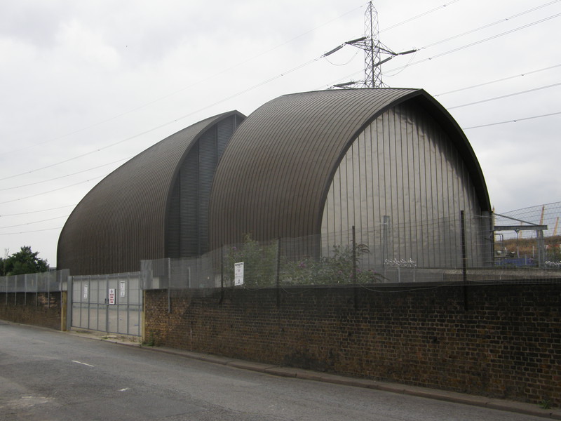
Returning to the main road, it's back to big hotels and large-scale development, but it's worth popping over the road to George Street, at the end of which is what looks like a stranded silver pier from the Thames Barrier. This is actually the mouth of the Jubilee line tunnel from North Greenwich station, which is just on the other side of the river (and nowhere near North Greenwich itself, confusingly). On the other side of the tunnel mouth is the old site of the Thames Ironworks and Shipbuilding Company, where HMS Warrior, the world's first all-iron warship, was built between 1859 and 1860. The yard's last ship was launched in 1911, and there's no trace of the yards left today, unless you count the football club that was set up for employees of the shipyard; originally called Thames Ironworks Football Club, they reformed in 1900 and renamed themselves West Ham United Football Club... and the rest is history.
Canning Town station is north along Silvertown Way, and it's a fun station to approach by foot. To the left are the raised DLR station platforms, and straight ahead is a brand new bus terminal that contains escalators down to the Jubilee line. The three stations here – DLR, Jubilee line and national rail – all date from the 1990s, though the first station on this site served trains from 1846 to 1888, as part of the Eastern Counties and Thames Junction Railway.
Canning Town to West Ham

After the seemingly constant industry of the last section, it's a relief to duck into the suburbs for the stretch to West Ham, though to be honest, this is not a terribly desirable place to live. There's a monstrous roundabout just north of the station, followed by some fairly forgettable modern terraces, and then a small park gives you a bit of breathing space before the suburbs start up again. The theme in this part of the world is council estate after council estate, a legacy of the 1930s slum clearances and the Blitz, which destroyed about 85 per cent of the area's housing (as the docks were a prime target for the Luftwaffe). There's no use pretending that this makes Canning Town a lovely place to explore on foot, as it doesn't; I didn't hang around for long, as there didn't appear to be anything to hang around for, particularly as Peta had hopped on the DLR at Prince Regent and headed for the comfort of a café at Stratford, leaving me to finish this last stretch on my own.

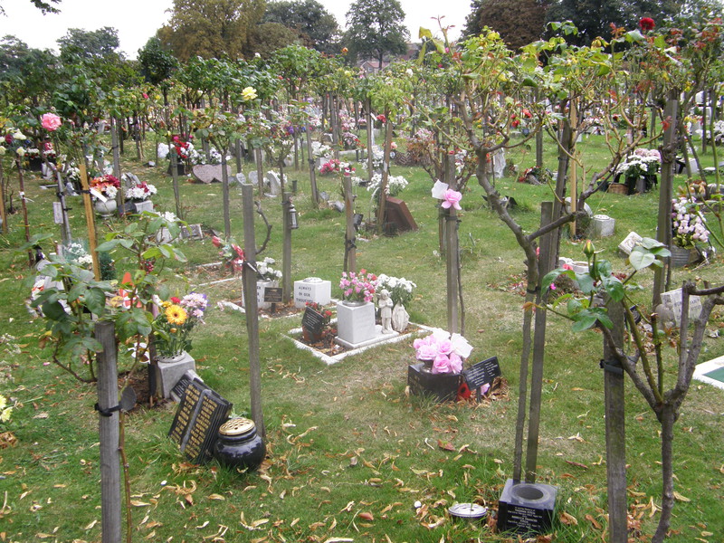
The housing estates start to give way to older housing at Bethell Road, just south of the pitches and parkland of Hermit Road Recreation Park, where drunks nurse their cans on lonely park benches. However, not much further north there's a real treat in the form of the East London Cemetery. Dating from 1871, this cemetery is a fascinating mix of the old and the new, with some of the more modern memorials including an old lady with a handbag, a darts board, and a child with his foot resting on a football. Near the entrance to the 33-acre site is a wonderful section that's lined with trees in neat rows, and on closer inspection each tree turns out to be a tiny grave, presumably for those who have been cremated. It's a charming place, and will eat up plenty of time for those looking for interesting graves (incidentally, Jack the Ripper's third victim, Elizabeth Stride, is buried here, though I didn't have time to track down the grave).
To the west of the cemetery, past yet more drab social housing, are the Memorial Grounds, a large green area made up of football pitches and parkland. This was the home stadium of Thames Ironworks Football Club from 1897 to 1900, and West Ham United from 1900 to 1904, when they moved to their current home at Boleyn Ground. The park is a pleasant place, with an intriguing grass-covered bridge in the north of the grounds, and if you look north and squint, you can just make out the Greenway, which I walked along on my District line walk from Bow Road to Becontree.
West Ham station wasn't a particularly interesting place when I visited it back in June, and it still isn't. The road to the station is lined with relatively modern apartment blocks, as befits an area next to a major Tube interchange, but the shops outside the station are unremarkable, and to the west is the spot where the Tablighi Jamaat Islamic movement is proposing to build the London Markaz, a mega-mosque for some 12,000 worshippers. Currently, though, it's wasteland, and rather limits the appeal of West Ham station.
West Ham to Stratford
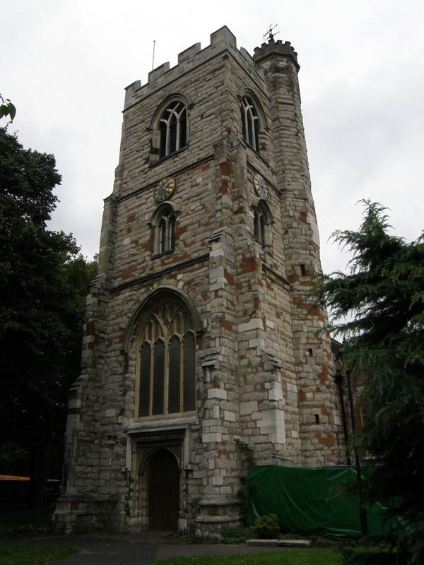
More housing estates kick in to the north of the station, after Manor Road passes under the Greenway. The skyline is dominated by two interesting examples of the art of the tower block, in the form of Brassett Point and David Lee Point, just off Abbey Road. These two blocks have recently been refurbished and don't look too bad, and if you can ignore the nearby blocks of pebbledash and dark brick, there are some pleasant terraces and new-build houses to be found in the mix. Just north of the blocks is New Plaistow Road, and on the other side is the lovely parish church of West Ham, All Saint's Church, which is well worth the detour. The church was once part of Stratford Langthorne Abbey, which was dissolved during the Reformation, and the current church tower dates from the early 15th century, while two chapels were added in the following century, since which time the church has remained broadly unchanged.
The pleasant greenery of Stratford Park is just to the north of the church, and it has a bizarre and very orange sculpture in the middle of the park that seems to be popular with large groups of black youths. Along West Ham Road there are some impressive modern buildings rising above the older architecture, and as you reach the Broadway, the bulk of the old court house leads to the Town Hall, which is currently hidden behind scaffolding and green plastic netting. This is the centre of Stratford, and it's a busy place, with the large spire of St John's Church, the obelisk-like Gurney Monument, and crowds of shoppers crowding into the shopping centre.

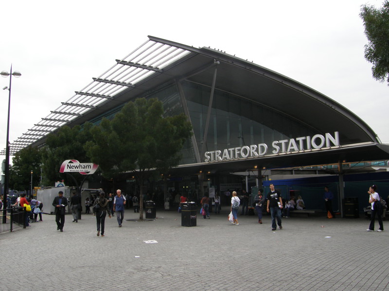
Stratford station is not far round the corner, past the impressive iron sculpture of the Railway Tree. As you approach, you get a really good feeling for the white tent-like roof over the new bus station, and then the bulk of the station looms into view, looking exactly as you'd hope the main station for the 2012 Olympic Games would look: modern and impressive. As I wandered into the vast courtyard in front of the station, Peta jumped up and waved from the other side, and that's when it hit me that I've finally finished this mad idea of walking the entire Tube network. After 45 days of walking along 12 lines, past 275 stations, and nearly 440 miles of putting one foot in front of the other, I'm off for a rest. Mind the doors!